What do you know?
What are the four main points on a compass?
The four main points on a compass are: north, east, south and west.
Key points
- A compass is used to work out direction. A four-point compass can give a rough direction whereas a sixteen-point compass is much more precise.
- Map symbols show what can be found in an area. Each feature of the landscape has a different symbol.
- Contour lines are lines that join up areas of equal height on a map. By looking at how far apart the contour lines of an area are, we can tell how steep or flat the land is.
How do we measure direction?
Video: Map symbols and directions
Map symbols and directions
Map symbols and direction
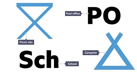
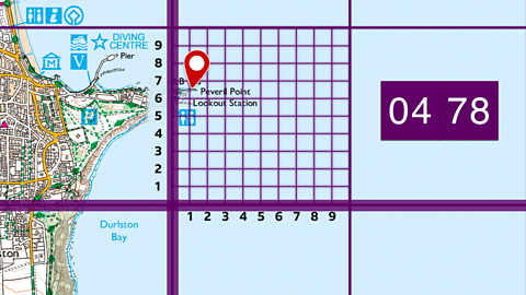
You can find where you are using an Ordnance Survey (OS) map. Features such as this information centre are identified on the map using symbols. This is a camping and caravan site. And here's a nature reserve.
On this map, different types of road are marked in different colours. This pink road is a main or A road. And this orange road is a secondary or B road. A full list of symbols is printed in the map key.
To work out which direction to go use the four-points of a compass. These are north, south, east and west. North is always at the top of the map. Halfway between the four main points are four other points: north-east, south-east, south-west and north-west. Together they make an eight-point compass. So if your phone runs out of charge you can still work out how to get from A to B.
Maps
A map is a drawing of a place as seen from above (from a bird's eye view). The Ordnance Survey (OS) is the national mapping agency for Great Britain. This organisation produces maps of different areas of the country in great detail. These maps are commonly used by geographers. A map is essential for telling us which direction to travel in.
Measuring Direction
Direction is measured using a An instrument with a magnetised pointer which shows the direction of north, east, south and west.. There are three types of compass:
A four-point compass - The four main compass points are north, east, south and west. A compass showing only these four points is a simple four-point compass.
An eight-point compass - Sometimes things need to be more precise. To be more precise when giving directions, an eight-point compass can be used. In addition to north, east, south and west, an eight-point compass includes north-east, south-east, north-west and south-west.
A sixteen-point compass - To be even more precise, we can use a sixteen-point compass. This includes north-north-east, east-north-east, east-south-east, south-south-east, south-south-west, west-south-west, west-north-west and north-north-west.
Question
Which organisation produces very detailed maps of Great Britain?
The Ordnance Survey (OS) is the national mapping agency for Great Britain and has been mapping large and small scale maps since 1745, initially for military purposes.
Quiz: Measuring direction
What are map symbols?
Maps contain a lot of information about the areas of land that they show. There are too many features to label everything using text, so we use map symbols.
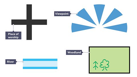
Map symbols can include letters, coloured areas, pictures or lines. These symbols can be used to show the location of different features such as roads, viewpoints, bus stations, train stations, schools and post offices.
Have a look at this slideshow to see examples of map symbols used on Ordnance Survey (OS) maps.
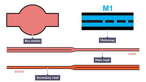
Image caption, These map symbols tell us about transport options in an area
1 of 3
Quiz: Map symbols
How do we show height on a map?
To show height on a map, A line joining places of equal height above sea level on a map. On Ordnance Survey (OS) maps, contour lines are usually orange. are used.
What are contour lines?
- Contour lines join areas of equal height and are shown in orange on an Ordnance Survey (OS) map.
- The number written on the contour line shows the height above sea level in metres.
- The interval between contours is usually five metres, although in A region having many mountains. regions it may be ten metres.
What do contour lines show?
The distance between contour lines shows how steep or flat the land is.
- If the contour lines are very far apart, it means the land is flat.
- If the contour lines are close together, it means the land is steep.
Spot heights and triangulation pillars
A map may also include The exact height of the land at a certain point, given in metres above sea level. This number is written in small black letters on a map. . These show the exact height (in metres above sea level) of a certain point on a map and are written in small black numbers.
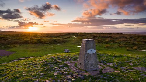
Sometimes A concrete pillar usually found at the highest point of the land. It is shown as a triangle on a map. are labelled on maps. A triangulation pillar is a concrete pillar that marks the highest part of the land. These were previously used by the OS to ensure that maps of Great Britain were as accurate as possible. They are shown on a map as a small blue triangle symbol.
Question
True or false? Contour lines join places that are an equal distance apart.
False. Contour lines join places of equal height. The height is measured in metres above sea level.
Quiz: Reading maps
Play the Planet Planners game! game
Make decisions for the planet in this KS3 geography game.

More on Geographical skills
Find out more by working through a topic
- count3 of 10
- count4 of 10
- count5 of 10