What is a fieldwork enquiry?
A fieldwork enquiry is when a topic is investigated by collecting data in the real world, usually outside of the classroom.
Key points
- All independent investigations should start with a An idea that can be tested. or an A question asked to gain specific information. .
- There are two types of data that can be collected: Raw data that has been collected first hand through fieldwork. and Data that has been collected by someone else through fieldwork..
- Before conducting any fieldwork, it is important to look at the risks involved.
Carrying out fieldwork and investigations
Video: Carrying out fieldwork and investigations
Carrying out fieldwork and investigations
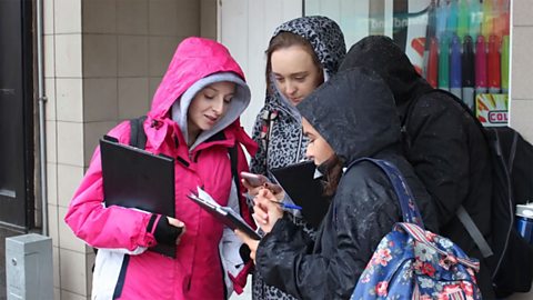
Fieldwork is a good way to find out about places, people and environments. It can be done anywhere but how you carry out your investigations is important.
Fieldwork starts with something you notice. For example, on this beach, there is more sediment on one side of this groyne than the other. The next step in fieldwork is to identify a key question or hypothesis. A hypothesis is a statement that can be tested and measured. For example, 'coastal processes have shaped this coastline.' A key question is similar but instead of a statement it is posed as a query. For example, 'which coastal processes take place along this coastline?'
Now it is time to collect evidence. Primary data is evidence you collect yourself. Secondary data is evidence from other people.
You need a range of evidence to answer the key question or prove or disprove your hypothesis.
Planning an independent investigation
Geographers sometimes leave the classroom and find things out for themselves. This is known as independent investigation or fieldwork. All good independent investigations start with a An idea that can be tested. or an A question asked to gain specific information. . These set out the aim of the investigation. A risk assessment should also be carried out before the investigation or fieldwork begins.
This is all part of the planning stage, which is only the first stage involved in geographical enquiry.
Choosing a hypothesis
A hypothesis is an idea that can be tested. A good hypothesis might look like this:
The area of Manchester city centre with the most pedestrians is Market Street.
A hypothesis should be clear and measurable. A poor hypothesis would be vague and difficult to measure. A poor hypothesis might look like this:
Manchester is nice.
Manchester is a very large area so this would be difficult to test. What is meant by 'nice' is not clear or measurable.

Choosing an enquiry question
An enquiry question is similar to a hypothesis. The difference is that rather than being a statement, it is posed as a question. An enquiry question might look like this:
What is the busiest part of Manchester city centre and why?
Completing a risk assessment
Before collecting the data that will help to prove the hypothesis or answer the question, it is important to assess the risks associated with collecting this data. For a physical geography investigation, for example, there may be risks associated with working near water. For a human geography investigation, there may be the hazard of working near traffic. By completing a risk assessment, you will be able to identify any possible risks and put in place Actions that could be taken. to prevent them. For example, pupils may be given a safety briefing before the fieldwork takes place or safety equipment may be used to help avoid accident or injury.
What should be done before collecting data in a geographical enquiry?
Before collecting data, you should create a hypothesis or enquiry question. It is also important to assess the risks associated with the collecting of data.
Data collection
An independent investigation is made up of two types of data: Raw data that has been collected first hand through fieldwork. and Data that has been collected by someone else through fieldwork..
Primary data
Primary data is data you have collected yourself. This is first-hand information and is also known as raw data.
There are many different ways to collect primary data.
Examples for a The branch of geography dealing with human activity. investigation include:
- counting the number of people in different parts of a town
- conducting a questionnaire
- completing a land-use map
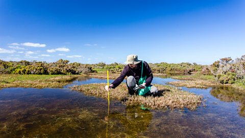
Examples for a The branch of geography dealing with the Earth’s natural features. investigation include:
- measuring the The speed at which something flows eg water in a river., depth or width of a river
- measuring pebble size
- completing a field sketch
Secondary data
Secondary data is information collected by someone else. This could include:

- newspaper reports
- A survey taken by the government every ten years that provides a detailed picture of the entire population. data
- crime data
- house prices
- flood maps
This type of data helps to provide some background to the investigation and can be compared to the primary data collected.
What is primary data?
Primary data is data collected first-hand by the researcher rather than by someone else.
Quiz: Carrying out fieldwork
Adapting data colleciton
Sometimes, a geographical enquiry needs to be adapted depending on the resources available. This might involve using sampling or virtual fieldwork to get the data that is needed.
Sampling
When collecting data, it is not always possible to measure everything, so many data collection methods involve Gathering a small amount of data when it is not possible to measure everything.. Sampling is about choosing what is going to be measured. For example, you might need to choose which pebbles on a beach will be used for an investigation into coastal processes.
There are three sampling strategies:
- Random sampling is where samples are randomly chosen and everything has an equal chance of being chosen for measurement. For example, every person is given an equal chance of being picked for a questionnaire or every pebble is given an equal chance of being measured.
- Systematic sampling is where a more regular sample is taken. For example, every tenth person is interviewed or river depth is measured every five metres.
- Stratified sampling is where Choosing a particular thing in an unfair way. is deliberately included so as to answer a specific question. For example, only interviewing tourists for an investigation into tourism.
Virtual fieldwork

It may not always be possible to go into the field and collect data. Some organisations such as universities and geographical societies have started to provide virtual fieldwork experiences. These include activities such as using virtual reality headsets to take part in virtual trips to field locations, such as glaciers and rainforests. Although it is not possible to collect primary data from these virtual trips, they are useful as they allow geographers to visit locations they would not otherwise be able to.
What are the three methods of data sampling?
There are three sampling strategies: random, systematic and stratified.
Quiz: Sampling
Play the Planet Planners game! game
Make decisions for the planet in this KS3 geography game.

More on Geographical skills
Find out more by working through a topic
- count8 of 10
- count9 of 10