What is a geographical enquiry?
Geographical enquiries can involve researching the human and physical environments. They are a way of investigating questions about the world we live in and learn how processes work.
There are six steps to follow in a geographical enquiry.
- Planning
- Fieldwork
- Processing and presenting data
- Analysing and interpreting data
- Conclusion
- Evaluation
Watch: Geographical enquiry - Part 1 video
Watch this short clip to learn about the planning and fieldwork steps in a geographical enquiry.
This is Jason. And this is Gwen. Today, they enter the exciting world ofãÎ geographical enquiry!
Donãt worry ã we can split the whole thing into six simple steps. Planning, fieldwork, processing and presenting data, analysing and interpreting data, conclusion, and evaluation. OK, Iãll slow down. Promise.
First, we need a plan. Start with a question to answer, or a hypothesis to test. You could investigate physical geography ã the landscape and climate. How a river changes, for example, as it moves downstream. Glad I could help, Gwen. Then thereãs human geography. How we interact with the world ãÎ or how weãre changed by it. Is there something you'd like to learn about the area where you live? Go Jason!
Keep it simple. You donãt need to reinvent the wheel - and background research will help you work out whether your aim is something you can actually achieve. A good way of going about it is to look at photographs of your location, or explore it online. Or you could actually go there, Jason.
Gwen reckons the width and depth of the river will increase as she moves downstream. This is a hypothesis. She also thinks that this will lead to a change in velocity. This is called a secondary hypothesis. All the coolest geographers have two or more.
Jason is asking a question. Have recent developments in his hometown had a positive or a negative impact? To answer it, he could look at changes in traffic, the number of tourists, or simply ask people what they think.
Youãll notice that Gwenãs taking a lot of measurements. So if, like her, your question or hypothesis deals largely in numbers, youãll be doing quantitative research. But Jason is relying more on finding out people's opinions - that's a qualitative approach. Both of these are just as valid, and suit different types of enquiries and data collection. Which approach is right for you?
Woah, Jason. Someone hasnãt made a risk assessment, identifying any potential dangers. Beforehand, youãll also need to make recording sheets for all that juicy data. Weãre talking width, depth and velocity tables for Gwenãs river study, and a questionnaire for Jason. Think of all the data you might possibly want to collect - you donãt want to be caught short when out in the field.
Think about the weather, too. Not that we ever stop thinking about the weather in Wales. It might impact your planning for the day, and the safety equipment and clothing youãll need to bring along. And if youãre really awesome, you could even create aãÎ risk assessment matrix!I would say itãs not as exciting as it soundsãÎ but cãmon. Look at it. It totally is.
The main purpose of fieldwork is the collection of primary data: any information that you collect yourself, on-site. The depth or width of a river, for exampleãÎ or the velocity. Go, tennis ball, go!
Remember that measurements should be taken a few times, just to make sure theyãre accurate. And if youãre taking photos donãt forget that mobile phones can record your precise location. That might be useful later on.
If youãre using a questionnaire, itãs best to ask people to tick a box rather than write long, rambling answers. Anything that makes the data easier to collect and analyse is fine by us.
And if you canãt ask everybody youãll need to collect data from a sample of the population and use either random or systematic sampling. A random sample for Jason would mean talking to anyone who catches his eye. A systematic sample would mean talking to every fifth, 10th, or 50th person who passes by.
Secondary sources, meanwhile, are put together by other people. Weãre talking maps, online research, and good old-fashioned books.These sources are particularly important in human enquiry, like Jasonãs project. We can see how an area changes by looking at census data, house prices, and crime rates.
Great! You've collected your data and it's all in one place. Once we start to analyse it - which is my favourite part - that data will begin to make sense, and we'll finally get some answers.
I told you this was exciting.
Planning
The first thing to do is to decide what to study. Enquiries can be about both the physical and the human environments. The physical environment may include studying rivers, coasts, sand dunes and mountains. The human environment can include investigating more urban locations in towns or cities.
Then choose a question to ask about what you have chosen to study. Or think of a hypothesis - a prediction that can be tested to see whether it is true or not.
Question
For an enquiry about traffic the question could be, ãDoes the time of day affect the type, amount and direction of traffic on a main road?ã
This question could be broken down further into sub-questions.
- What types of traffic use the main road?
- How many vehicles pass by in a set time?
- How does the direction of traffic compare at different times in the day?
For an investigation of a river the question could be, ãHow does a river change as it moves downstream?ã
The question could be broken down further into sub-questions.
- Does the velocity of a river change along its course?
- What happens to the width and depth of the river as you go downstream?
- Does the size and shape of pebbles change along the course of a river?
Hypothesis
You could choose a hypothesis to test whether it is true or not.
For an investigation into the amount of traffic travelling along a main road, the hypothesis could be, ãI think there will be more traffic driving towards the city centre during the morning rush hourã.
In an investigation of a river, the hypothesis could be, ãI think that as I travel downstream, the river will become wider and deeperã.
Choosing the right location
Once an enquiry question has been chosen it is important to find a suitable, accessible location to carry out the investigation. Careful consideration needs to be given to choosing the best location and time.
For a traffic enquiry looking at a main road going in and out of a city centre, questions to consider when choosing a location could include the following.
- Where is the safest place to stand to collect the data?
- Can all of the traffic be seen from this location?
- Is the location accessible?
When carrying out a river study, select sites where the river is safe to access.
Look at the weather forecast and decide whether it is safe to carry out your data collection.
Risk assessment
In a risk assessment, you identify possible hazards and figure out whether they're likely to cause damage or harm.
A risk assessment must be completed before starting any investigation. It is necessary to consider all the challenges and dangers, such as:
- where is a safe location to stand to collect the data?
- what will the weather be like on the day of the data collection?
- will you be working alone or as part of a group?
- what will happen if someone falls over and hurts themselves?
| Potential hazards | Risk | Probability | How to reduce the risk | |
|---|---|---|---|---|
| 1. Heavy rain - hypothermia | 3/5 | 3/5 | Check the weather forecast. Bring a rain jacket and an umbrella. Wait for a dry day. | |
| 2. Getting lost | 2/5 | 4/5 | Plan the route carefully. Take a map. Tell someone where you are going. Take a phone. |
Data
Data is the information collected for the enquiry. The data must answer the question that you have asked.
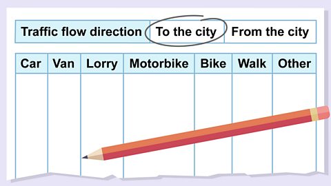
It is important to consider how to collect the data. In a traffic enquiry you might record the number of cars, lorries, buses, motorbikes, bikes and pedestrians that pass during a 30 minute period.
Data should be reliable. This means that the data gathered must be accurate so when conducting a traffic enquiry you need to consider:
- how can data be collected free from errors?
- will results be accurate if you try and count traffic going in both directions?
- can data be collected with a partner to make it more accurate?
Primary and secondary data
Data that is original and collected first-hand is called primary data. For example a tally chart of the amount of traffic you observe travelling along a main road or measurements you make of a riverãs width and depth.
Data that has been previously collected by someone else and made available is called secondary data. For example, data in a book, census data or data from a reliable website.
It is important when collecting data to get a balance between both primary and secondary data.
Quantitative and qualitative data
The data that is collected can be quantitative or qualitative.
Quantitative data is an amount or value and is expressed in numbers, eg the velocity of a river, the number of cars or the amount of litter in a particular location. This can be collected using methods such as environmental surveys, tally charts or by measuring.
Quantitative data can be quick to collect, good for representing in a graph and easy to compare. However, this data often does not provide enough depth on its own so it is useful to use both quantitative and qualitative data together to get a good balance.
Qualitative data is expressed as pictures, words and descriptions. It can be collected in different ways, eg by interviewing a person about their personal viewpoints, collecting questionnaires, drawing sketches or taking photographs. This information is much more descriptive and can give greater insight into the environment or community. This type of data is very informative, but it can be more difficult to represent in a graph.
Fieldwork
The main purpose of fieldwork is collecting primary data - any information that you collect yourself, on-site. There are several things to consider when doing this.
Sampling techniques
The sampling technique should be chosen carefully because it helps to remove bias, which is when one result or answer is encouraged over others. If data is gathered without justifying the sampling method used, it may be regarded as being unreliable and the results of the enquiry may be considered unfair or inaccurate.
There are three main types of sampling.
- Systematic sampling ã collecting data in order and at regular intervals, eg every fifth house, or every one mile along a river.
- Random sampling ã choosing a location or person to collect data from at random.
- Stratified sampling ã dividing sampling into groups, eg choosing three locations for collecting data along a road or river in advance.
Collecting quantitative data
When collecting data for an investigation, it is important to consider how the data is collected.
For human investigations both qualitative and quantitative methods are used.
Quantitative data collection methods include:
- pedestrian flows
- tally charts
- environmental surveys
- land use surveys
When collecting quantitative data, for example in a traffic enquiry, a data collection sheet can be used.
Special data collection methods may be used depending on the location and the focus of the enquiry. If completing a river investigation you could measure the:
- cross-sections
- wetted perimeter
- width and depth of the river
- velocity
- pebble shape and size
- gradient
Collecting qualitative data
Methods for collecting qualitative data include:
- questionnaires, which are a written or printed questions with a choice of answers
- interviews, when people are asked about their opinions face-to-face
- emotion mapping, which records the researcherãs feelings about locations, eg giving a score expressing how safe they feel in different places
Equipment
It is important to consider what equipment is needed to complete the enquiry so that you have everything you need for the investigation. The equipment needed will depend on the nature of the investigation.
For example, for the traffic enquiry only a clipboard, data collection sheet, pencil and rubber are needed to record the data.
But for a river study the list of equipment would be longer because items such as ranging poles, tape measure, metre ruler, flow metre and stopwatch would also needed.
Whatever the investigation, check the weather forecast beforehand so that you are dressed appropriately.

Geographical enquiry - Part 2
You can learn about the next four steps in a geographical enquiry in Geographical enquiry ã Part 2
More on Geographical skills
Find out more by working through a topic
- count2 of 2