This collection of Funky Facts from Go Jetters includes information about some of the UK’s most significant places and landmarks, with examples from each of the four countries that make up the UK.
Tower Bridge, in the capital city London, is a landmark that crosses England’s longest river, the River Thames.
Caernarfon Castle is a famous castle in North Wales, built hundreds of years ago; while Bishop Rock is the smallest island with a building on it in the world. Then there's Loch Ness, a very long and deep, natural water-feature in Scotland, that is the famed home of the imagined monster, Nessie.
Another natural feature, the Giant’s Causeway in Northern Ireland, also attracts thousands of visitors each year as people want to go and see the amazing hexagonal shaped rocks that stretch into the sea; and lastly there's the White Cliffs of Dover, made of soft chalk that is slowing getting worn away by the sea and the weather.
Supporting resource from Twinkl
This collection is supported by a free teaching resource from .
This is an external link. The ¬È∂π‘º≈ƒ is not responsible for the content.
Download for free using the link below:
Tower Bridge, England
Giant's Causeway, Northern Ireland
Loch Ness, Scotland
Caernarfon Castle, Wales
Bishop Rock, Isles of Scilly
Cheddar Gorge, England
White Cliffs of Dover, England
The United Kingdom. video
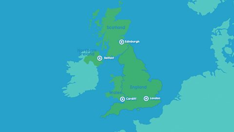
This short animated film for 5-7 year-olds offers pupils a tour of the four countries that make up the United Kingdom. It identifies the capital, the flag and a key human and physical feature of each country.
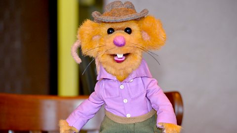
William Whiskerson. collection
In this classic series of short films William Whiskerson takes pupils on a tour of the UK to look at different landscapes and their uses. Suitable for teaching 5-7 year-olds.
Teacher Notes
Before Watching
Discuss what a landmark is and talk about what makes a feature special and why. Are there any local landmarks near to the school or in your village or town that pupils can talk about and describe?
Find the school on a map and talk about where you live and your address. Zoom out to show and name the different countries of the UK: England, Wales, Scotland and Northern Ireland.
Ask pupils what well known landmarks they have visited locally or further away. Discuss which landmarks pupils are most familiar with and where they are. Use photographs, storybooks and models to help describe features.
Using pupils’ own holiday experiences, discuss what a tourist is and why they might like to visit landmarks.
After Watching
Use atlases and maps to locate and mark the four countries of the UK on a map.
NB: Great Britain is the term used to describe England, Wales and Scotland. The UK is the term used for Great Britain and Northern Ireland together.
Locate the landmarks using Google Earth and other digital mapping software. Annotate landmark locations with labels on digital maps and add images.
Use paper maps too and create a large display map for the classroom; add landmark locations to this with pupils’ labels and drawn or painted images.
Create local-scale, table-top maps using paper, paint, collage or other media. Add labels to show and name landscape features.
Make and add models of the landmark you are learning about. Younger pupils can use small-play figures with the maps to develop vocabulary, stories and curiosity.
Ask pupils to plan a trip to ‘visit’ a chosen landmark, thinking about how they would get there and what transport might be needed. Discuss with pupils what you might need to pack for the visit.
Ask pupils to sketch or paint their own landmark images and use these to create their own postcards. Write about what ‘visiting’ the landmark is like and post them back to the school using the school address.
Select a landmark and ask pupils to describe it and what it is made from. Discuss whether anything near where you live is made from a similar material or formed in a similar way.
Take each country of the UK: England, Wales, Scotland and Northern Ireland and ask pupils to collaborate using atlases and simple research to create their own simple maps for each.
Encourage pupils to find out and add some key information such as capital cities, highest mountains, important rivers and cities.
Encourage pupils to add personal information too, such as places they’ve visited or where they have family living.
Identify, using images, which landmarks are human or built features e.g. bridges, towers and castles, and which are natural or physical features e.g. lakes, rocks and mountains.
Compile a class top ten of favourite landmarks and mark them on a world or UK map as appropriate.
Master Skills
- Naming and describing what places are like (landmarks and features).
- Locating landmarks using paper or digital maps; globes and atlases.
Thinking Questions
- What is it that makes a landmark special?
- If you had to either find or design a landmark for the school grounds, what would it be or look like and why? Where would you put it and why?
Supported Learning and SEN
Children could work in pairs or mixed ability groupings so that they benefit from peer support.
A range of media and maps could be used to help identify, name and locate landmarks. Making or using 3D models could help pupils describe what a landmark is like.
Pupils’ ideas might be recorded using audio or video media as well as through writing.
Extend This Project
Ask pupils to create their own fact files about each landmark, gathering images and information through research. Each landmark in this series has unique properties, geographical vocabulary and can stimulate a range of different ideas.
Extend the idea of landmarks to a global scale and ask pupils to find out about important landmarks across the world. Map them as a class.
These short film clips contribute to the current national curriculum requirements in the Foundation Stage Understanding the World and KS1 geography in England; the Foundation Stage World Around Us in Northern Ireland; the Foundation Phase Knowledge and Understanding of the World in Wales, and at Social Studies 1st level in Scotland.
The clips are especially pertinent to the Areas of Learning and subject requirements of geography but provide opportunities to develop English and mathematics knowledge and skills in meaningful contexts across all UK curricula.
These clips and ideas will help develop pupils’ curiosity and build on their early experiences of the world around us.
The clips and ideas contribute to UK curricular aspects relating to cultural understanding, particularly about people and places.